Region Guessing Bucharest
This guide provides an overview of common and easily recognisable metas that can be used to pinpoint an arbitrary location within Bucharest as accurately as possible. This may be particularly useful for players of Geoguessr and similar games, as well as casual detectives, stalkers, enthusiasts, or individuals who accidentally find themselves in Bucharest without any prior knowledge of their location but with a desire to learn more.
Please note that the contents of this guide describe the situation as of 2025. As the city finds itself in a constant state of evolution, the same information may not be applicable at a later stage. Neither the author nor any subsequent distributor of this material will be held accountable for an incorrect plonk resulting from either dealing with imagery that does not yet exist, imagery that may be considered niche enough not to be outlined here, or generally any unforeseen circumstance or accident.
Identifying Bucharest
Refer to a more general guide for identifying Romania; in short, driving on the right, European car plates with one blue strip on the left, predominantly generation 4 imagery, Latin alphabet containing diacritics Ă/ă, Î/î, Â/â, Ș/ș, Ț/ț, the latter sometimes erroneously displayed as Ş/ş and respectively Ţ/ţ, predominantly fair skinned inhabitants, top-level domain .ro, flag 🇷🇴 (not to be confused with Chad, Andorra, Moldova), frequent usage of Dacia cars.
Bucharest can be differentiated from other Romanian cities by the frequency of tall buildings, density of cars, polluted air, tram lines, and being the only Romanian city with a metro system. A red double-decker can be seen in tourist areas.
Regional clues
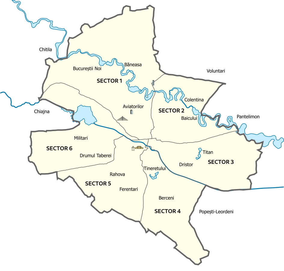
Bucharest is split into six radial sectors, with sector 1 in the north and numbers increasing clockwise.
It is predominantly urban, with some neighbourhoods such as Colentina, Bucureștii Noi or Ferentari being populated by houses more often than apartment buildings.
Street signs are usually blue with a green outline and often indicate the containing sector.
Less ornate types of street signs can usually be seen further away from the city centre and towards the peripheries. Note that street signs are typically present on the first and/or last building of a street.
Trash bins can sometimes be used to identify the sector.
Recognisable neighbourhoods and structures
The Palace of the Parliament (depicted on the right, as seen from afar) is a massive structure located near the centre of Bucharest. Together with the nearby National Cathedral, they can often be seen from various points in the nearby areas, making them useful for accurate geoguessing.
Aviației and the surrounding areas between Floreasca Lake and the Aurel Vlaicu airport are the only region with skyscrapers. The Sky Tower (an oval glass building, the tallest structure in Bucharest) can be visible from many streets.
The Basarab bridge, whose pylons reach 84 metres, can be seen from many streets around Gara de Nord.
Bucharest Tower Centre is another rather visible tower in the Kiseleff area.
Cotroceni is a small, rich-looking neighbourhood consisting of large, older houses. It can be recognised by the general lack of shops.
Dorobanți, also a rich house-filled neighbourhood, which can be differentiated from Cotroceni by slightly wider streets and larger buildings.
Southern Rahova almost exclusively consists of perpendicular streets and small houses. The only apartment buildings in Rahova are the ones surrounding the main artery, as well as in the northeast. The nearby Ferentari shows similar-looking surroundings, but with less regularly oriented streets.
Another neighbourhood exhibiting a grid-based street layout is Bucureștii Noi; however, this can be easily differentiated as it is richer and more modern-looking.
Buildings and infrastructure
This is a map showing the distribution of apartment buildings, colour-coded by the number of floors.
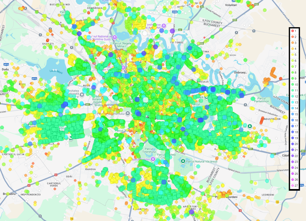
As you can see, the centre of Bucharest has many older buildings, featuring various architectures such as neoclassicism, art deco, neoromanian, and neogothic. Communist apartment buildings are primarily seen in the following regions: Militari, Drumul Taberei, Crângași, Pajura, the central part of Sector 5, Berceni, Tineretului, Vitan, Dristor, Titan, Pantelimon, and Tei. Modern buildings are often seen in the north.
Bollards vary from region to region and cannot be used to recognise a neighbourhood.
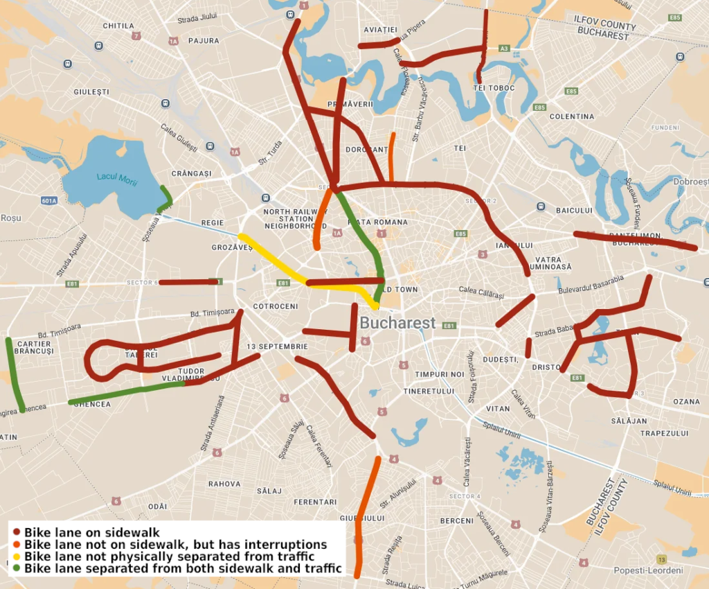
Bicycle paths are extremely rare, with only a handful of them scattered throughout the city.
Nature
Rats are commonly found in and around the Dâmbovița River, especially in areas such as Piața Unirii. Note that areas with a significant amount of trash might also attract rats.
Cockroaches are present everywhere throughout the city, including inside most homes, and so they cannot be used as a meta for geoguessing.
Gulls can often be seen, especially in areas close to water such as the northern lakes, Morii Lake or Dâmbovița River. Rare species of birds have been reported in the Văcărești Delta.
Geography
The topography of Bucharest is generally flat, with only a few hills concentrated around the central area: Dealul Mitropoliei near Unirii, the nearby Dealul Spirii where the Palace of the Parliament is located, Dealul Filaret within the Carol Park, etc..
Although an extremely rare occurrence, the Carpathian Mountains are known to be visible towards the north on very clear days.
(To be continued.)